


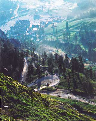
The Tevis Cup trail ascends from the Truckee River (elevation 6,200 feet) through the Squaw Valley ski resort area to Emigrant Pass (elevation 8,774 feet), a climb of 2,550 vertical feet. Historic accounts reveal that the ascent from the Squaw Valley floor for emigrants and miners whether by horse or wagon was steep and difficult as the footing was troublesome over loose rubble and around boulders.
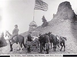 Atop the summit at Emigrant Pass a rock monument stands, built by Bob Watson in 1931, at an elevation of 8,774 feet, appropriately named Watson Monument. The blocky volcanic outcropping nearby on the southern crest was named Fort Sumter in the early days of the Civil War, when California miners passed over the summit from the west upon rumor of a silver discovery known as the Squaw Valley Excitement.
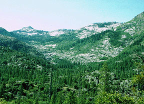
To the south of Emigrant Pass is Squaw Peak and to the north is Granite Chief. To the east, an unforgettable scene of grandeur and color meets the eye with peerless Lake Tahoe in a sapphire setting among snow-covered peaks and rugged mountains.
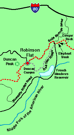
 From Emigrant Pass to Robinson Flat the trail, for the most part, follows the historic route of the Placer County Emigrant Road built in 1855. From the pass, you may choose to travel a southwesterly direction, descending to Little American Valley which lies at the extreme head of the Middle Fork of the American River, at an elevation of over 7,400 feet. It is a beautiful valley with a wild stream that is seemingly guarded by the highest mountain peaks in this region. During times of late spring, snowfall or lack of thaw, the trail through the little valley is sometimes impassable. Early day sheepherders and pack strings found an alternate route, now used by the Tevis Cup Ride, to the north of the valley on the sunny south slope of Granite Chief and Needle Peak. Trail conditions dictate which trail to travel upon.
 Part-way down from the pass the trail enters the Granite Chief Wilderness Area set aside by the United States Congress in 1984 as apart of the California Wilderness Act. Granite Chief was established to protect the wildlife environment including deer, bear, pileated woodpecker, blue grouse, marten, goshawk, and rainbow and brown trout and encompasses some 15,000 acres to the south of the trail. The wilderness designation ended several decades of controversy between preservation and commodity user groups.
To the west, beyond the cut banks and channels of streams and springs that develop around the slopes of the little valley, the trail cuts over the shoulder of Picayune Bluff with a breathtaking view from the rim rock. This pioneer landmark whose name means "small bluff," was what every early-day traveler looked for as a guide over the trail. From this vantage point through cathedral-like rock formations there is a beautiful view of pristine Picayune Valley and Mt. Mildred to the south.
The trail works its way from bench to bench up the high ridge under talus slopes below Needle and Lyon Peaks. It is at this point that the trail leaves the Granite Chief Wilderness.
Over the ridge the trail passes near the privately owned logging campsite of Hodgson's Cabin, built in 1946. Eventually the trail emerges on the very spine of the high divide separating the high country watersheds of the North and Middle Forks of the American River at Soda Springs Pass (sometimes referred to as Wubbena Pass), with a great view north and south of a hundred miles of Sierra Nevada mountain peaks. Ahead, a break in the western ridge provides a view of the deep and mighty Royal Gorge, under the high ramparts of Snow Mountain that marks yet another pioneer landmark of the trail.
The trail holds its course for several miles along the very summit of the Foresthill Divide. The ridge is narrow, which displays sweeping views of great canyon depths on either side below. Looking back to the southeast one can find the small and lovely glaciered Picayune Valley that runs to the northeast of the reddish colored shale canyon wall of Mildred Ridge, with a trail of its own up through the middle along Picayune Creek that follows beside several cascades and waterfalls. This divide also serves as the northern boundary of a state wildlife refuge. Along this narrow volcanic ridge the trail repeatedly climbs and descends through forest and rock.
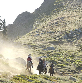
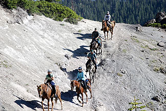
A quarter of the way along the ridge a horseback rider or hiker/runner might be surprised to find an obstacle that makes one wonder how anyone in the old days wanted to pass this way. A large volcanic cone outcropping with a steep and narrow passage and deep canyons on either side stands as a landmark known as Cougar Rock. Despite the poor footing hundreds of horses have traveled over this solid-based rock outcropping that resembles the shape of a cougar's head. Over time riders and hikers have come to prize a photograph of themselves at this dramatic panoramic site.
 Another difficult section of terrain along the ridge is a place called Elephant's Trunk. The name reflects the trail's resemblance to the profile of an elephant's trunk: a slight dip and a steep incline, so sharp that a horse must climb for a few hundred feet up loose rubble and rock, on which, having a lava base, their flat shod hoofs fortunately do not slip. It is equally difficult for those afoot. A look back to the east finds the scenery positively breathtaking.
A short distance past Elephant's Trunk you reach the Baker Ranch-Soda Springs Road. At this juncture the trail forks in two directions: The historic route of the Tevis Ride, to the southwest, crosses U.S. Forest Service (USFS) Road 96 to travel for 15 miles along Red Star Ridge and through the beautiful old growth forest of Duncan Canyon to Robinson Flat. The other route, currently used by the Tevis ride, continues westward along the summit road of the Foresthill Divide for about 7 miles to reach Robinson Flat.
Next: Robinson Flat to Last Chance