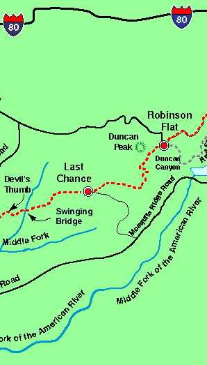


 The Western States Trail separates from the Placer County Emigrant Road at Robinson Flat and heads southwest along a dirt road, a former wagon route used in the late 1800s. It then passes over a summit just to the south of Duncan Peak and to north of Little Bald Mountain before making its way westward along Barney Cavanaugh Ridge (also referred to or known as Cavanah Ridge).
The ridge was named for a Last Chance miner, famous for discovery of the big Bonanza in the Klondike. Beautiful views of surrounding canyons and mountains can be seen in every direction. The trail descends gradually while meandering along a ridge top through a forest of tall pines that also provides a glimpse of the great Sacramento Valley. The first site of a mining operation in this area is located a few hundred feet off the trail at Barney Pits. The historic trail route further down Cavanaugh Ridge through Deep Canyon and Grizzly Mine is expected to be restored for future use to avoid this section of road to Last Chance.
The ridge is without water until "Dusty Corners," where the route turns south on USFS Road 44 into Deep Canyon and continues toward Last Chance.
The road eventually leads to the now-abandoned town of Last Chance.Perched on the top of an elevated promontory on the very brink of a tremendous drop-off, Last Chance seems like a jumping-off place. Last Chance overlooks the north fork of the Middle Fork of the American River between Grouse Creek on the south and Deep Canyon on the north in one of the wildest areas of this region.
Next: Last Chance to Deadwood