 This section of the Western States Trail was listed in the National Register of Historic Places on June 25, 1992, by the U.S. Department of the Interior. There are five interpretive signs along the trail to educate the public about the trail and its significance during the early development of this region and the Gold Rush. It is worth noting the cooperative effort between the U.S. Forest Service, the Western States Trail Foundation and Western States Endurance Run Foundation that resulted in determining that this section of trail was eligible for listing in the National Register of Historic Places. An informative brochure is available at no cost from any of these non-profit organizations.
The path leading from Last Chance to Michigan Bluff was once a toll trail, with the toll collected by a Scotsman named Duncan Ferguson and his wife Jessie, who owned the hotel and bar at Deadwood called the Half-Way House. All of those using the trail -- whether walking, riding horseback, driving cattle or pack trains -- were asked to pay a toll, and the money was expended to keep the trail in good condition. Occasionally animals that crowded too fast on the trail would lose their footing and fall to their death in the canyon below.
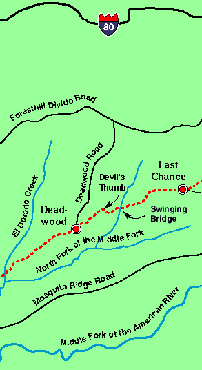
The trail from Last Chance follows a lumber road leading to the Pacific Slab Mine, which remained active longer than any other hydraulic mining operation in California. There are several cabins here, but the mine has not been worked for several years. Here the narrow trail drops quickly down some 2,000 feet, which so many gold miners pioneered with picks, shovels and black powder. It is not quite two miles down the switch back trail into the wooded canyon of the North Fork of the Middle Fork of the American River, with places so steep and stony that some horsemen occasionally jump off their mounts and run down, leading their horses. Watch carefully for the placement of your feet on the narrow trail. At the bottom of the canyon is the so-called Swinging Bridge,suspended over the deep, swift flowing river. The water is crystal clear and the fishing grand. The thunder of the water is a pleasant sound.
In making the equally steep climb out of the canyon on well-graded switch backs, riders will stop for perhaps a minute every three to four hundred yards, enabling their horses to catch their breath.
Near the top of the canyon wall is Devil's Thumb, a landmark named for the hellish conditions that once existed here. The 'thumb' is a large volcanic rock outcropping standing nearly 50 feet in height. Surrounding the 'thumb' is evidence of the Devil's Basin hydraulic Sourdough and Basin mining pits that eroded the canyon side in the seemingly never-ending search for gold. Once in view of Devil's Thumb you have nearly completed the long ascent from the deep canyon below.
The trail then follows the divide southwest toward the former town site of Deadwood, more than a mile from Devil's Thumb. Deadwood is at the tip of this narrow mountain spur high above the yawning chasms of El Dorado Canyon and the North Fork of the Middle Fork of the American River.
Next: Deadwood to Michigan Bluff


