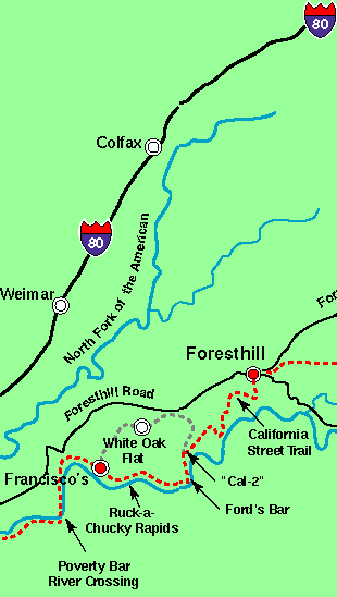


In 1974, the section of trail from Foresthill to Auburn was designated by the Secretary of the Interior as a National Recreational Trail. Due to the development of the area, particularly in Todds Valley to the west of Foresthill, a break was made from the historic route. As a result, the trail was re-routed in 1981 into the Middle Fork canyon along a system of known historic trails, wagon roads and water ditches.
At the end of California Street in Foresthill the trail begins its descent along Baltimore Mine Ridge into Dardanelles Creek. For a short while the trail follows chalky bleached terrain through a corridor of baking manzanita. Directly west, you will be able to see the orange and white cliffs near Todds Valley scoured bare by hydraulic mining. In approximately three miles, after a switch back trail down the steep canyon wall to Dardanelles Creek, the trail follows a water ditch which once served as a source for the electricity needs of Foresthill. The Foresthill Electric Company, founded in the early 1920s, built these ditches between Dardanelles and Pond Creeks and formed a forebay at the juncture at the point of the ridge to house the captured water high above the river before its 1,000 foot descent to a hydro-electric turbine located along the side of the river. The historic Eagle Creek Hydroelectric Project turbine generated enough electricity to satisfy the needs of the town and several local mines. The remains of this plant were discovered and restored in 1981, and today, a modern-day means of hydroelectric power generation has taken the place of the technology of the 1920s.
After Pond Creek the trail levels off and parallels the Middle Fork on a long, remote stretch. Several old mining roads leading to the river cross the trail. This portion of trail follows the wide canyon rim between 1,000 and 1,300 feet above the river.
Note: The 1997 Tevis Cup Ride made use of the original trail through the Todds Valley area, making its ascent from a point known as "Cal-2," right before the switchbacks described below. For the 1997 Ride, the vet check usually held at Francisco's was held at White Oak Flat. The trail route then proceeded downhill to Francisco's. The remaining description applies to the "California Street" trail route to Francisco's.
The trail makes its descent on a well-graded switch back trail to Peachstone Gulch and Fords Bar. A narrow trail along water ditches and miner paths built during the Gold Rush takes you down river to Squaw Gulch. An abandoned wagon road stays close to the river, through moist stream beds lined with horsetails, giant ferns, and rock walls dotted with succulents. This stretch is an exciting, scenic trail that takes you past the awesome boulder-jammed Ruck-A-Chucky Falls to Oregon Bar. It is near this location in the summer of 1848 that a party of Oregonians first found a tremendous treasure of gold. The Greenwood/Ponderosa bridge which later spanned the river at Oregon Bar was carried away by a flood in the winter of 1964.
A short distance above Oregon Bar is Francisco's, a small mountain meadow above the river.
Next: Francisco's to the Lower Quarry Vet Check