


What is the origin of the Tevis Cup and Haggin Cup Awards?
The Tevis Cup was named for Lloyd Tevis (1824 - 1899) by his grandson Will Tevis, a prominent San Francisco businessman and early benefactor of the Ride. The trophy is awarded to the first rider to complete the 100 mile Ride whose mount is "fit to continue." It was first awarded in 1959 to Nick Mansfield, riding Buffalo Bill, an eleven year old Thoroughbred Cross gelding.
Lloyd Tevis and James Ben Ali Haggin, college friends from Kentucky, met again in the California gold fields in the early 1850s. By 1853 Haggin and Tevis had moved to San Francisco where they established a successful law practice. The men also married sisters, Susan Gano Sanders and Elizabeth Jane Sanders of Kentucky, further strengthening their bond. Haggin raised thoroughbred horses on his ranch in Sacramento, and in 1886 his horse, Ben Ali, won the Kentucky Derby.
In 1964, Louis Haggin of Versailles, Kentucky, donated the James Ben Ali Haggin Cup in honor of his grandfather. It is awarded to the horse among the first ten finishers that is considered, as Lloyd Tevis stated, "to be in the most superior physical condition."
How have finishing times changed over the years?
We have records of the winning times beginning with the 7th annual Ride in 1961 and continuing to the present. Winning times for all years are published each year in the Participants' Guide that is sent to each Ride entrant. (A copy of the current Participants' Guide can be purchased via the Tevis Store.) Winning times, since 1961, plus individual ride times for all finishers since 1996 are available as part of the Trivia pages of this web site.
How has the trail changed, if at all?
For the most part, the route is as it was in 1955. The Trail still goes from the Lake Tahoe Area to Auburn, but the years of population growth in the Sierra have taken their toll: Certain route modifications had to be made.

The Ride originally started at the Tahoe City Community Center, literally at the shoreline of Lake Tahoe. In 1970, the starting line was moved to Squaw Valley, a few miles away, where it remained for the next 20 years. The only exception was in 1983, when the ride began at Soda Springs (Serene Lake). Emigrant Pass was still closed that year due to an unusual late Spring snow. The section of trail known as the California Loop, from California Street in Foresthill to the vet check at Francisco's, was first used in 1982. 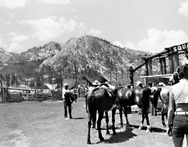 It replaced the route through Todd Valley Estates, which was rapidly being developed with new homes and paved roads at the time. In 1990, the starting line was moved to its current location at the newly-established Robie Park. In order to retain the 100-mile Ride length, the leg that ran along Red Star Ridge and back through Duncan Canyon into Robinson Flat was dropped in favor of the present, more direct route along the Soda Springs Forest Service Road. The 1990 Ride was probably the toughest of all because of the unknowns involved with the route changes. Temperatures on the trail that day were also the hottest in the Ride's history. Hal V. Hall was first to finish that year, with a completion time of 15:56, the longest first place finish in the Ride's history.
  The 1997 Ride route included a temporary change. The original Western States Trail through Todd Valley was used by connecting from "Cal 2" to White Oak Flat. The vet check, usually held at Francisco's, was moved up hill to White Oak Flat. Riders then rode down to rejoin the usual route toward the Poverty Bar river crossing. The 1998 Ride route added a scenic stretch of single track between Dusty Corners and Last Chance, now known as "Pucker Point" for it's breathtaking viewpoint above the Deep Canyon gorge. The 2003 Ride initiated the most recent change to the trail. After departing Robinson Flat, the course used to follow Cavanaugh Ridge, a rocky single track stretch of several miles. Riders would then cross the Deep Canyon area following a Forest Service road to reach Dusty Corners. Now the course bypasses Cavanaugh Ridge by continuing on FS Road 43 out of Robinson Flat and then following a single track trail with good footing to reach Dusty Corners. The distances involved remain the same, but riders can make better time on the new route.
It is said that the Ride has 19,000 feet of "up" and 22,000 feet of "down". Is this true?
Pretty close. When the ride used to start at Squaw Valley the numbers were 17,040 feet of climbs (about 5,194 meters) and 21,970 feet of descents (about 6,696 meters). Now that the starting line has moved to Robie Park, the overall elevation numbers are probably about the same, but new exact numbers have not been computed.

Are there any records regarding trail/weather conditions?
The weather conditions from year to year are mostly the same: HOT and DUSTY. We have tried to get historical data from public sources, such as the US Forest Service, but records are sketchy, at best. The Ride has started keeping track of the Temperature and Humidity information at the major Ride checkpoints. Data is available on this site for the 1997 and 1998 Rides.
Have endurance times changed or are they constant, as for racehorses?
The first-to-finish times do change with the trail conditions, weather, etc. In 1996, for example, Erin McChesney had a winning ride time of 15:38 hours compared to her winning 15:19 hours in 1991. Her horse, Cougar's Fete, was the same and so was the trail route. With so much of the Tevis Trail being single track, isn't it possible to get stuck behind a slower rider and end up not finishing? Maybe 60% of the 100 miles is single-track, but the rest is graded fire roads, for the most part. Even in the single-track sections, most riders will let you by if you ask, and there's a safe place ahead. As for the opportunity to make up time, there are more places along the course to trot than what most riders are willing to take advantage of. The challenge is more about holding a workable pace and saving your horse. Moving in the back of the pack is no guarantee that you will finish in time. Yet, far and away more (over 98%) of the horses pulled are pulled at the vet checks along the way. Less than 2% are disqualified for overtime at the finish line or along the way. Being caught behind a slow group from time to time is not likely to prevent you from finishing, provided that you pass when it's safe and then pick up the pace. Which is not to say that you needn't plan your pace or follow a strategy about being ahead/within/behind the "pack," – especially at the start. Much depends on your own style of riding, your horse's best pace, your combined level of conditioning, your attitude and even dumb luck.
Is it true that you have to eat dust the whole way?
The trails are dusty at that time of year. No getting around it. The good news is that by Cougar Rock (1/4 the way into the Ride) riders are spread out enough that the dust has a chance to settle between groups of riders. Don't make too much of the dust factor. It's part of the deal, but not a show-stopper. The trail crosses the American River below Foresthill.
Would my horse and I have to swim to get across?
No. Placer County Water Agency, operator of the dams upstream of the crossing, hold back much of the normal flow of water, starting the morning of the ride. By the time the first horses arrive at the crossing the water is at a low level and you don't have to swim. Because the Ride is held in late July/early August, heavy Spring snowmelt is usually not a problem. The Western States 100 Mile Run, on the other hand, is held the last weekend of June and at least once has had to hire a rafting company to get the runners across safely. Note: When pre-riding the trail in the weeks before the ride it is likely that you will have to swim the crossing. The middle fork of the American river has become a popular destination for commercial white water rafting, and the water agency often increases water output on the weekends for this very reason.
What are the best places to park my horse trailer to ride parts of the Western States Trail on my own?
There are several good places to park, tack up and ride the WS Trail. Starting with the Finish Line and working back up the trail to the more remote sections, they are as follows:
- The Auburn Overlook parking area is directly adjacent to the Tevis Finish Line location. The fairgrounds parking areas are a few hundred yards farther away, not so good if coming to pre-ride the trail. Take Auburn-Folsom Rd. from the Old Town/Auburn Courthouse area, go left onto High Street and go past the fairgrounds main entrance. Go right onto Pleasant Street and go about 1/2 mile. Look for a left turn into the parking lot, about 50 yards after you cross the railroad tracks. Use the gravel parking area, not the paved one nearby.
- Highway 49 Crossing: Although it is possible to access the trail where it crosses Highway 49, near the American River North Fork/Middle Fork confluence (No Hands Bridge area) there aren't any safe places to park a rig and tack up.
- Driver's Flat is a quarter mile off the Foresthill divide highway, about half way to Foresthill, and has good parking. The Driver's Flat turnoff is well marked. It is about a 30 minute ride from there down to the Francisco's/Rucky-Chucky area of the trail. You can also follow the trail south along the River to Poverty Bar and back. ("And back" because you may well not be able to safely cross the river when you get there.)
- White Oak Flat is a little further along on the way to Foresthill and has plenty of room to park your rig. It's also about a 30 minute ride downhill from there to Francisco's. Finding WOF is a little tricky. Refer to the driving instructions and map provided for the annual Fun Ride.
- Foresthill is very horse friendly. You can park your rig nearly anywhere in town, but to ride the California Street trail your best bet is to just park on California Street itself. As you enter the town of Foresthill, bear off onto the alternate main street that parallels the main drag through town, and then turn right at the first "real" street you come to, California Street. Turn left at the end of the block and park along the right side on the wide grassy shoulder. The trail begins back the other way (the right-hand turn from California Street) just around the corner where the pavement ends. You will cross another paved street (the road that goes to Mosquito Ridge) but the trail picks up again on the other side. If possible, arrange a rig shuttle with a friend so that you can ride one way on the California Street trail and meet your rig at Drivers Flat. (Friend drives separate car to Drivers Flat and parks there, jumps in your rig and you all continue to FH. Friend sees you off and then drives rig back to Drivers Flat for you.) Or, you can park at the old mill site at the other end of town, where the vetcheck is held during the Ride. (The millsite is private property -- please leave it cleaner than you found it!) This location is better if you plan to ride toward Michigan Bluff. In this case you need to ride downhill along Bath Rd (on the upper side of the millsite) until it makes a sharp turn to the right. The trail is straight ahead off that turn.
- Michigan Bluff: The road to Michigan Bluff is a right turn a few miles further along the Foresthill divide road. It's a twisty road and quite steep in sections. Be sure your brakes are in good shape. You can park on the grass shoulder in the middle of town -- just don't leave a mess. The trail is to the left at the end of the main street, next to where you can make a u-turn with your rig. Note: The High Country Trails (those above Michigan Bluff) are covered with snow from about November until late May/early June.
- Devil's Thumb/Last Chance: Further along the divide road there are turnoffs that will take you in to Last Chance and Devil's Thumb, but it's about seven ugly miles of dirt road; probably more trouble than it's worth pulling a rig.
- Robinson Flat: Follow the divide road all the way to its end (about a 45 minute trip from Foresthill). There are numerous places to park at Robinson, but if it's your first time there, pull off to the roadside, get out and scout it on foot. The nicest places to park and/or camp are down near the meadow, but the roads are narrow and you need to be good at dodging rocks and trees as you maneuver to a good spot. The best riding out of RF is the old Tevis trail down into Duncan Canyon. Next best is Soda Springs Road, the graded road to the northeast -- you can make a day trip to Cougar Rock and back, but be sure you know how to find the trail turnoff from the graded road. The other option is to head down the trail toward Cavanaugh Ridge.
- Squaw Valley: You can park your rig at Squaw Valley and ride up past Watson's Monument and into the Granite Chief Wilderness. There is a graded parking area on the left after you pass the riding stables, just before the ocean of asphalt parking. Trail access is at the far end of the asphalt. There are several graded service roads that wind their way up the draw toward High Camp (where the cable car ends up.) If you are not familiar with which of these roads are used during the Ride, the SV Corp maintenance crews are always around and may be able to point the way for you. One hint: Riding from the valley floor resort area, you will intercept the current Tevis Trail route about half way up the mountain, near where the main service road crosses Squaw Creek over a bridge made out of a flatbed railroad car.
Where can I go to watch the Ride in progress?
Not all of the Ride Course is accessible to the general public on Ride Weekend. Many of the vet checks are restricted to Ride officials only, due to limited space for parking and to the need to keep the narrow access roads clear for fire and rescue equipment. Members of the press are asked to obtain a press pass in advance by emailing the WSTF office or calling (530) 823-7282.
You can, however, see a lot of the Ride (and related activities) first hand:
- Starting at Robie Park on the Friday of Ride Weekend, you can observe the vet-in process and browse the numerous vendor stalls that are set up there for the day.
- The Foresthill millsite vetcheck, where there is a one-hour hold, is an excellent location to watch the Riders come through. The front runners start to arrive at mid-afternoon, Saturday. There is ample parking in the millsite area. You can also watch the Riders as they head down along the main street of Foresthill, after leaving the millsite vetcheck.
- You can then move to the Finish Line, near the Auburn Fairgrounds, to see the top 10 come in, starting about 8:00 pm.
- Finally, the public is welcome to attend the Awards Ceremony begin at 2:00 pm on Sunday afternoon in the Upper Pavilion area at the Auburn Gold Country Fairgrounds. Starting at 1 pm there is a picnic-style banquet offered by the Lions Club Host; tickets are for sale "at the door." Also, there are vendor stalls set up nearby for the day.
How can I find out more about the sport of Endurance Riding?
Two great resources on the Web are www.endurance.net and the American Endurance Ride Conference site www.aerc.org
Also, while browsing that site, look for information on joining the email list known as Ridecamp.Books available on the subject of Endurance/Performance Riding include:
- Veterinary Manual for the Performance Horse by Dr. Nancy S. Loving, DVM, about $75
- Go the Distance: The Complete Resource for Endurance Riders by Nancy S. Loving, DVM, about $26
- The Endurance Horse Daily Planner by Karen Paulo Bumgarner, new edition.
- The Complete Guide to Endurance Riding and Competition by Donna Snyder-Smith and Valerie Kanavy, about $28
- Endurance Riding from Beginning to Winning by Lew Hollanders, about $17
- Endurance Riding: From First Steps to 100 Miles by Clare Wild, about $40
How can I volunteer to help out with the Ride?
Volunteers are the lifeblood of the Tevis Cup Ride. About 600 people participate each year in the presentation of the Ride -- more than two per rider! If you are uncertain which type of assistance you would like to offer, take a look at the list of functions shown in the Ride Organization page of this site. If you know what you'd like to do, or if you just want to help wherever needed, fill out our online Volunteer Signup form.
Please Note:
As you might imagine, the Ride is a huge effort that relies completely on volunteers. There are Head Volunteers who provide the leadership for each of the many vetchecks, as well as other areas of Ride activity. These "HV's" necessarily operate with a good deal of independence, but under the overall guidance and coordination of the Ride Secretary and Ride Manager.
All of the contacts from folks who would like to volunteer are collected by the WSTF office and published as a list to all HV's. Some HV's have a very stable organization from year to year and do not need additional help or replacements. It is up to each HV to make contacts from the list as needed.
The down side of this decentralized approach, of course, is that it is difficult to know who on the list has been contacted -- or not, as the case may be. Also, the need to pull in additional volunteers may not be known until late in the weeks leading up to Ride Day.
